Estate Maps, 1750s-1900s
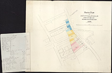
| Title: | Sketch plan of Spittalfield divided into three lots referred to in articles of Roup, 1869. With particulars of the property of Spittalfield attached |
| Pagination: | 1 manuscript map : col. ; 49 x 59 cm (attached letter 26 x 21 cm) |
| Shelfmark: | Acc.10225/330 |
| Notes: | We are very grateful to Sutherland Estates for permission to display this map on our website. Sutherland Estate mapping home page. |
| Zoom Into Map: | Click on the map to view in greater detail. |