Estate Maps, 1750s-1900s
| Name: | Richmond, James |
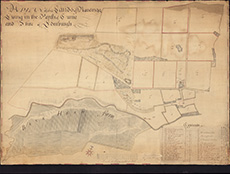
| Title: | A plan of the lands of Ravelrigg lying in the Parish of Currie and Shire of Edinburgh: 1764 |
| Imprint: | 1764 |
| Pagination: | 1 map; 54 x 75 cm |
| Shelfmark: | Acc.3995 |
| Zoom Into Map: | Click on the map to view in greater detail. |