Estate Maps, 1750s-1900s
| Name: | Robertson and Ballantine. |
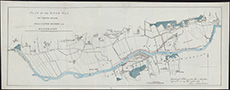
| Title: | Plan of the River Tay and adjacent grounds between Castle Menzies and Bolfracks. |
| Imprint: | Edinburgh : Robertson & Ballantine's lithog [1823] |
| Pagination: | 1 map : hand col. ; 24 x 65 cm |
| Shelfmark: | EMS.s.586 |
| Zoom Into Map: | Click on the map to view in greater detail. |