Estate Maps, 1750s-1900s
| Name: | Whyte, George. |
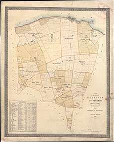
| Title: | Plan of the lands of Pitullie and Pittendrum lying in the parish of Pitoligo and County of Aberdeen / by George Whyte, 1844. Henderson, Draughtsman & Lithographer. |
| Imprint: | [Aberdeen, 1844] |
| Pagination: | 1 map ; 524 x 423 mm |
| Shelfmark: | EMS.s.477 |
| Zoom Into Map: | Click on the map to view in greater detail. |