Estate Maps, 1750s-1900s
| Name: | Ainslie, John, 1745-1828 |
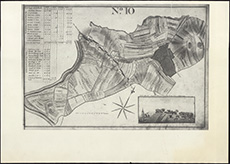
| Title: | [Plan of the] Runriggs of Corshill / [by J. Ainslie] |
| Imprint: | Drawn 1789. |
| Pagination: | 1 map ; 240 x 363 mm |
| Shelfmark: | EMS.s.457 |
| Zoom Into Map: | Click on the map to view in greater detail. |
| Name: | Ainslie, John, 1745-1828 |
| Title: | [Plan of the] Runriggs of Corshill / [by J. Ainslie] |
| Imprint: | Drawn 1789. |
| Pagination: | 1 map ; 240 x 363 mm |
| Shelfmark: | EMS.s.457 |
| Zoom Into Map: | Click on the map to view in greater detail. |
© 2024 National Library of Scotland, registered Scottish Charity, No. SC011086