Estate Maps, 1750s-1900s
| Name: | Strachan, Thomas. |
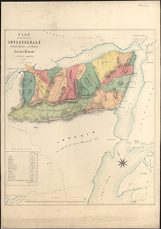
| Title: | Plan of the lands of Inverscadale, Stroncrigan and others in the Parish of Kilmalie and County of Argyle. 1858 / Schenck & Macfarlane, lithogrs. drawn by T. Strachan, Surveyor. |
| Imprint: | Edinburgh, 1858. |
| Pagination: | 1 map ; 661 x 562 mm |
| Shelfmark: | EMS.s.331 |
| Zoom Into Map: | Click on the map to view in greater detail. |