Estate Maps, 1750s-1900s
| Name: | Henderson, Andrew. |
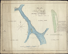
| Title: | Plan of Stokie Banks being part of the River Findhorn / by Andw. Henderson ... (Sinclairs lithog.). |
| Imprint: | Edinburgh, 1823. |
| Pagination: | 1 map ; 382 x 517 mm |
| Shelfmark: | Signet.s.056 |
| Notes: | We are very grateful to the WS Society for their permission to display this map online. View Signet Library collection maps of Scotland held at NLS. |
| Zoom Into Map: | Click on the map to view in greater detail. |