County maps, 1580s-1950s
| Field | Content |
|---|---|
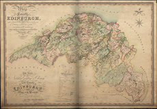
| Name: | Sharp, Thomas. |
| Title: | Map of the county of Edinburgh, made on the basis of the trigonometrical survey of Scotland / surveyed in the years 1827 and 1828 ... by ... Thos. Sharp, C. Greenwood and Wm. Fowler. (Engraved by John Dower). |
| Imprint: | London, 1828. |
| Pagination: | 1 map ; 678 x 1004 mm. |
| Shelfmark: | Signet.s.028 |
| Notes: | We are very grateful to the WS Society for their permission to display this map online. View Signet Library collection maps of Scotland held at NLS. |
| Zoom Into Map: | Click on the map to view in greater detail. |