Estate Maps, 1750s-1900s

| Name: | Forrest, William (fl. 1799-1832) |
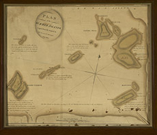
| Title: | Plan of the Summer Isles Copied from the Original by Wm Forrest Ld Surveyor, Edinr 1805 |
| Imprint: | Copied: 1805 |
| Pagination: | 1 ms. map : hand col.; 55 x 65 cm. |
| Shelfmark: | NOSAS CL.3 |
| Notes: | Scale: 1:12245. It is not clear what the "original" map is, from which this was drawn. The Summer Isles do not appear on Peter May's 1756 survey of Coigach, part of the Cromartie Estate at the time of the 1746 forfeiture. Courtesy of the North of Scotland Archaeological Society. |
| Zoom Into Map: | Click on the map to view in greater detail. |