Estate Maps, 1750s-1900s
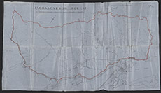

| Title: | Inchnacardoch Forest |
| Imprint: | 1934 |
| Pagination: | 1 manuscript map: col.; 62 x 112 cm. |
| Shelfmark: | Lovat387 |
| Notes: | 1:10732. (5000' = 14.2 cm ). Part of a disposition, kept in the Estate Office Disposition Book. Written on map: Plan referred to in the foregoing disposition in favour of the County Council of County of Inverness, dated the seventeenth day of April nineteen hundred and thirty-four (1934) Shows the boundaries of Inchnacardoch Forest.. Courtesy of Lovat Highland Estates and the North of Scotland Archaeological Society. View Lovat Highland Estates mapping |
| Zoom Into Map: | Click on the map to view in greater detail. |