Estate Maps, 1750s-1900s

| Name: | Ordnance Survey |
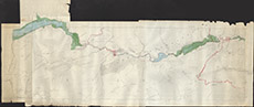
| Title: | [GLenstrathfarrr Dams] |
| Imprint: | 1950s ? |
| Pagination: | 1 map: col.; 72 x 215 cm. |
| Shelfmark: | Lovat375 |
| Notes: | 1:6336. (6" = 1 mile ). A map constructed (date unknown) from separate sheets of 2nd ediion OS maps showing the intended construction of the dams along Glen Strathfarrar. Courtesy of Lovat Highland Estates and the North of Scotland Archaeological Society. View Lovat Highland Estates mapping |
| Zoom Into Map: | Click on the map to view in greater detail. |