Estate Maps, 1750s-1900s

| Name: | Ordnance Survey |
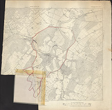
| Title: | [Bruiach Beaufort] |
| Imprint: | 1920s ? |
| Pagination: | 1 map: col.; 74 x 73 cm. |
| Shelfmark: | Lovat371 |
| Notes: | 1:6336. (6" = 1 mile ). Part of the 2nd edition 1905 OS sheet showing a boundary in red from Balblair south to Boblainy. No indication what the boundary means. Courtesy of Lovat Highland Estates and the North of Scotland Archaeological Society. View Lovat Highland Estates mapping |
| Zoom Into Map: | Click on the map to view in greater detail. |