Estate Maps, 1750s-1900s

| Name: | Mackay, George G. |
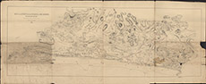
| Title: | Map of the District between Inverness & Fort Augustus on the South Side of Loch Ness |
| Imprint: | 1866 |
| Pagination: | 1 map; 71 x 174 cm. |
| Shelfmark: | Lovat367 |
| Notes: | 1:31780. (2" = 1 mile ). Standard printed map by W & AK Johnston, Lithographers, Edinburgh and "compiled by George G Mackay, 1866". Shows SE side of Loch Ness, with Inverness at left, Fort Augustus at right. The various estate ownerships of the land is overdrawn onto the map.. Courtesy of Lovat Highland Estates and the North of Scotland Archaeological Society. View Lovat Highland Estates mapping |
| Zoom Into Map: | Click on the map to view in greater detail. |