Estate Maps, 1750s-1900s
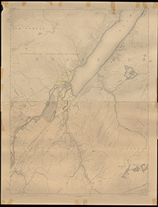

| Title: | [Fort Augustus] |
| Imprint: | 1910s ? |
| Pagination: | 1 map; 100 x 52 cm. |
| Shelfmark: | Lovat318 |
| Notes: | Two almost identical maps, rolled inside each other, showing a highlighted area of land on Loch Ness side, east of Inchnacardoch. Courtesy of Lovat Highland Estates and the North of Scotland Archaeological Society. View Lovat Highland Estates mapping |
| Zoom Into Map: | Click on the map to view in greater detail. |