Estate Maps, 1750s-1900s

| Name: | Ordnance Survey |
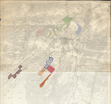
| Title: | [Woods around Kilmorack & Kiltarlity] |
| Imprint: | 1960s ? |
| Pagination: | 1 map: col.; 125 x 98 cm. |
| Shelfmark: | Lovat317 |
| Notes: | 1:6336. (6" = 1 mile ). Conjoined 2nd edition OS maps, showing various estate woods coloured differently. Courtesy of Lovat Highland Estates and the North of Scotland Archaeological Society. View Lovat Highland Estates mapping |
| Zoom Into Map: | Click on the map to view in greater detail. |