Estate Maps, 1750s-1900s

| Name: | Gordon, David, 1820-1893 |
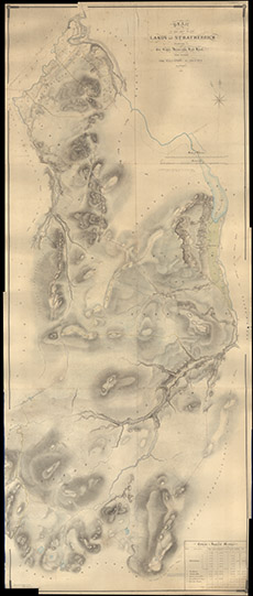
| Title: | Plan of that part of the Lands of Stratherrick Belonging to the The Right Honourable Lord Lovat, which extends from Ballanrhu to Allt-Our inclusively |
| Imprint: | 1862 |
| Pagination: | 1 manuscript map; 260 x 109 cm. |
| Shelfmark: | Lovat315 |
| Notes: | 1:6336. (50 chains = 6.25" ). Estate map showing the long glen, Strath Fechlin & Strath Killin, south of Whitebridge. Courtesy of Lovat Highland Estates and the North of Scotland Archaeological Society. View Lovat Highland Estates mapping |
| Zoom Into Map: | Click on the map to view in greater detail. |