Estate Maps, 1750s-1900s
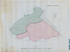

| Title: | Farley Woods |
| Imprint: | 1910s ? |
| Pagination: | 1 map: col.; 41 x 55 cm. |
| Shelfmark: | Lovat296 |
| Notes: | An undated map showing shaded areas of the Farley Wood with deisgnation for felling. Scale 1:10588. (100 chains = 19 cm ). Courtesy of Lovat Highland Estates and the North of Scotland Archaeological Society. View Lovat Highland Estates mapping |
| Zoom Into Map: | Click on the map to view in greater detail. |