Estate Maps, 1750s-1900s

| Name: | Ordnance Survey |
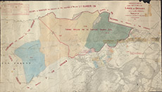
| Title: | Ordnance Sheets showing Copy Plan of the Lands of Urchany and the Hill Grounds of Farley etc, situated in the Parish of Kilmorack |
| Imprint: | 1897 |
| Pagination: | 1 map: col.; 66 x 117 cm. |
| Shelfmark: | Lovat291 |
| Notes: | An interesting map - overprinted on a 6" 1st edition OS map are the 1852 allocation of lands between Urchany & Farley, from David Gordon's map. This is again over-written with Ground Applied for by Crofters and stamped Crofters Commission 14 May 1897. So, Scale 1:10560. (6" = 1 mile ). Courtesy of Lovat Highland Estates and the North of Scotland Archaeological Society. View Lovat Highland Estates mapping |
| Zoom Into Map: | Click on the map to view in greater detail. |