Estate Maps, 1750s-1900s

| Name: | Gordon, David, 1820-1893 |
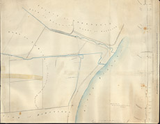
| Title: | [Tomich Burn] |
| Imprint: | 1889 |
| Pagination: | 1 manuscript map: col.; 74 x 95 cm. |
| Shelfmark: | Lovat287 |
| Notes: | Shows plans for embankment of Beauly River at Tomic, with resultant ditches and burns. Superscribed with: This is an old Draft Plan which has been revised, etc Scale 1:1056. (10 chains = 7.5" ). Courtesy of Lovat Highland Estates and the North of Scotland Archaeological Society. View Lovat Highland Estates mapping |
| Zoom Into Map: | Click on the map to view in greater detail. |