Estate Maps, 1750s-1900s

| Name: | Gordon, David, 1820-1893 |
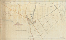
| Title: | Plan of the Lands of Tomich and Lettoch with part of Muir of Ord, 1867 |
| Imprint: | 1867 |
| Pagination: | 1 manuscript map: col.; 74 x 120 cm. |
| Shelfmark: | Lovat286 |
| Notes: | Map used in lease agreement 1867. Scale 1:2400. (20 chains = 6.6" ). Courtesy of Lovat Highland Estates and the North of Scotland Archaeological Society. View Lovat Highland Estates mapping |
| Zoom Into Map: | Click on the map to view in greater detail. |