Estate Maps, 1750s-1900s

| Name: | Gordon, David, 1820-1893 |
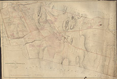
| Title: | Plan of the Lands of Ruifour, Teavarran and Cragganvallie, 1853, The Land Improved Then and Since being coloured Red, 1871 |
| Imprint: | 1853 |
| Pagination: | 1 manuscript map: col.; 79 x 115 cm. |
| Shelfmark: | Lovat285 |
| Notes: | Shows fields and tenancies of the three settlements in Glen Convinth Scale 1:2437. (20 chains = 6.5" ). Courtesy of Lovat Highland Estates and the North of Scotland Archaeological Society. View Lovat Highland Estates mapping |
| Zoom Into Map: | Click on the map to view in greater detail. |