Estate Maps, 1750s-1900s
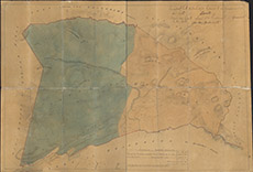

| Title: | [Sketch of Parts of Urchany] |
| Imprint: | 1870 |
| Pagination: | 1 manuscript map: col.; 53 x 76 cm. |
| Shelfmark: | Lovat279 |
| Notes: | Shows the lands of Urchany, shaded in two different colours. Map used in 1870 agreeement between Lovat and John Henry Greville Smyth (There is a JHG Smyth who was a rich Sussex naturalist, who may have rented the land) Scale 1:6336. (40 chains = 5" ). Courtesy of Lovat Highland Estates and the North of Scotland Archaeological Society. View Lovat Highland Estates mapping |
| Zoom Into Map: | Click on the map to view in greater detail. |