Estate Maps, 1750s-1900s
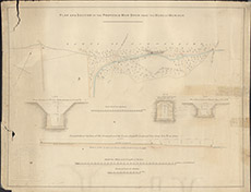

| Title: | Plan and Section of the Proposed Main Drain from the Moss of Moniack |
| Imprint: | 1830s ? |
| Pagination: | 1 map: col.; 50 x 64 cm. |
| Shelfmark: | Lovat277 |
| Notes: | Shows sections and elevations of a proposed deep and covered drain from Moniack across the lands of Achnagairn Scale 1:2376. (30 chains = 10" ). Courtesy of Lovat Highland Estates and the North of Scotland Archaeological Society. View Lovat Highland Estates mapping |
| Zoom Into Map: | Click on the map to view in greater detail. |