Estate Maps, 1750s-1900s
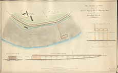

| Title: | Plan, Elevation and Sections of a Proposed Shipping Pier at Phopachy Point on the Beauly Firth |
| Imprint: | 1839 |
| Pagination: | 1 map: col.; 62 x 97 cm. |
| Shelfmark: | Lovat273 |
| Notes: | Shows a proposed shipping pier - wooden trackway leading to a substantial stone pier. If this was ever built there are now no traces. Scale 1:533. (400' = 9" ). Courtesy of Lovat Highland Estates and the North of Scotland Archaeological Society. View Lovat Highland Estates mapping |
| Zoom Into Map: | Click on the map to view in greater detail. |