County maps, 1580s-1950s
| Field | Content |
|---|---|
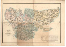
| Name: | Chapman, James, fl. 1784-1834 Johnson, William, fl. 1806-1840 |
| Title: | Plan of the island of Lewis reduced from Mr Chapman's survey |
| Imprint: | [Edinburgh] : Forrester & Ruthven, 1821 |
| Pagination: | 1 map : col. ; 586 x 808 mm. |
| Shelfmark: | EMS.s.543 |
| Notes: | James Chapman's original survey was originally ca. 1807-9, and this reduced plan was published in 1821, and lithographed ca. 1840 |
| Zoom Into Map: | Click on the map to view in greater detail. |