Estate Maps, 1750s-1900s

| Name: | Gordon, David, 1820-1893 |
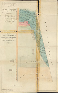
| Title: | Plan of the Eastern Part of Muir of Ord Market Stance showing in Red the Building Plots, 1872 |
| Imprint: | 1872 |
| Pagination: | 1 map: col.; 65 x 41 cm. |
| Shelfmark: | Lovat259 |
| Notes: | Map used in lease agreeement 1872. Scale 1:640. (200' = 3.75" ). Courtesy of Lovat Highland Estates and the North of Scotland Archaeological Society. View Lovat Highland Estates mapping |
| Zoom Into Map: | Click on the map to view in greater detail. |