Estate Maps, 1750s-1900s

| Name: | Ordnance Survey |
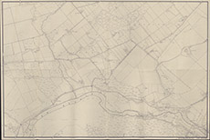
| Title: | [Kilmorack] |
| Imprint: | 1950s ? |
| Pagination: | 1 map; 67 x 99 cm. |
| Shelfmark: | Lovat234 |
| Notes: | Apparently an OS map, probably 2nd edition, showing Kilmorack and Balblair. However very similar in style to Lovat096 which is definitely drawn in 1950's Scale 1:2534. (25" = 1 mile ). Courtesy of Lovat Highland Estates and the North of Scotland Archaeological Society. View Lovat Highland Estates mapping |
| Zoom Into Map: | Click on the map to view in greater detail. |