Estate Maps, 1750s-1900s

| Name: | Gordon, David, 1820-1893 |
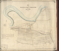
| Title: | Plan of the Farm of Wester Lovat and Donaldston situated in the Parish of Kirkhill |
| Imprint: | 1861 |
| Pagination: | 1 map: col.; 85 x 96 cm. |
| Shelfmark: | Lovat230 |
| Notes: | A detailed plan of the two farms, within the now embankment dyke. Map used in a lease agreement 1862. Scale 1:2376. (30 chains = 10" ). Courtesy of Lovat Highland Estates and the North of Scotland Archaeological Society. View Lovat Highland Estates mapping |
| Zoom Into Map: | Click on the map to view in greater detail. |