Estate Maps, 1750s-1900s

| Name: | Gordon, David, 1820-1893 |
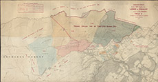
| Title: | Ordnance Sheets shewing Copy Plan of the Lands of Urchany and of the Hill Grouds of Farley etc situated in the Parish of Kilmorack |
| Imprint: | 1852 |
| Pagination: | 1 map: col.; 66 x 133 cm. |
| Shelfmark: | Lovat215 |
| Notes: | Interesting that although the 1st edition OS map of this area was surveyed in 1872, nevertheless this 1852 map is based on OS survey at 6"=1mile. Very similar to Lovat291 Scale 1:10560. (6" = 1 mile ). Courtesy of Lovat Highland Estates and the North of Scotland Archaeological Society. View Lovat Highland Estates mapping |
| Zoom Into Map: | Click on the map to view in greater detail. |