Estate Maps, 1750s-1900s
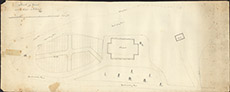

| Title: | Sketch of Ground around the Chapel at Eskadale, 1837 |
| Imprint: | 1837 |
| Pagination: | 1 manuscript map; 40 x 100 cm. |
| Shelfmark: | Lovat210 |
| Notes: | The sketch shows the original unmodified chapel in 1826, including ground that is about to be made into cemetery. Scale 1:1188. (30 chains = 5" ). Courtesy of Lovat Highland Estates and the North of Scotland Archaeological Society. View Lovat Highland Estates mapping |
| Zoom Into Map: | Click on the map to view in greater detail. |