Estate Maps, 1750s-1900s

| Name: | Gordon, David, 1820-1893 |
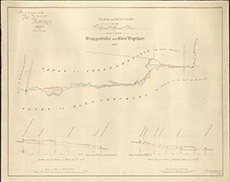
| Title: | Plan and Sections of the Proposed March Burn between the Lands of Cragganvallie and Glen Urquhart, 1861. |
| Imprint: | 1861 |
| Pagination: | 1 map: col.; 66 x 83 cm. |
| Shelfmark: | Lovat188 |
| Notes: | NB The Uncultivated Lands on the Crofts is shaded Green, and the Arable is Uncoloured. Comments: shows rectangular division of croftsat what is now called Camault Muir, nr Kiltarlity Scale 1:2400. (20 chains = 6.6" ). Courtesy of Lovat Highland Estates and the North of Scotland Archaeological Society. View Lovat Highland Estates mapping |
| Zoom Into Map: | Click on the map to view in greater detail. |