Estate Maps, 1750s-1900s
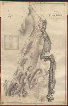

| Title: | Plan of Moor of Clunes as laid out into lots for Improvement, 1847 |
| Imprint: | 1847 |
| Pagination: | 1 manuscript map; 118 x 76 cm. |
| Shelfmark: | Lovat184 |
| Notes: | 1:3168. (4 chains = 1" ). Courtesy of Lovat Highland Estates and the North of Scotland Archaeological Society. View Lovat Highland Estates mapping |
| Zoom Into Map: | Click on the map to view in greater detail. |