Estate Maps, 1750s-1900s

| Name: | Mackenzie, William (1787-1837) |
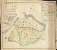
| Title: | Plan of the Lands of Culligran |
| Imprint: | 1799 |
| Pagination: | 1 manuscript map: col.; 60 x 56 cm. |
| Shelfmark: | Lovat172 |
| Notes: | A coloured map, with table of contents, of Culligran in Strathfarrar, from the "bottom of Beinnuarchard" in the west, to the "March Burn" in the east. Scale 1:1584. (14 chains = 7" ). Courtesy of Lovat Highland Estates and the North of Scotland Archaeological Society. View Lovat Highland Estates mapping |
| Zoom Into Map: | Click on the map to view in greater detail. |