Estate Maps, 1750s-1900s
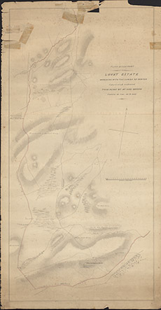

| Title: | Plan of that Part of the Lovat Estate marching with the lands of Newton. |
| Imprint: | 1830s |
| Pagination: | 1 manuscript map; 103 x 54 cm. |
| Shelfmark: | Lovat146 |
| Notes: | Undated map showing the march between Lovat and Newton, west of Blairnahenachrie near Englishtown. Details of map taken from the plans by Mr Geo Brown taken in 1798-99 & 1800. although this map later than that. Scale 1:3168. (20 chains = 5" ). Courtesy of Lovat Highland Estates and the North of Scotland Archaeological Society. View Lovat Highland Estates mapping |
| Zoom Into Map: | Click on the map to view in greater detail. |