Estate Maps, 1750s-1900s

| Name: | Gordon, David, 1820-1893 |
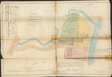
| Title: | Sketch of that Piece of Ground on Bridgend which is Possessed by John Forsyth and his Assignees, 1854. |
| Imprint: | 1854 |
| Pagination: | 1 map: col.; 37 x 54 cm. |
| Shelfmark: | Lovat135 |
| Notes: | Map used in 1854 agreement. Two sets of handwriting on the map, top left and bottom right provide further details of the signatroies. Scale 1:396. (3 chains = 6" ). Courtesy of Lovat Highland Estates and the North of Scotland Archaeological Society. View Lovat Highland Estates mapping |
| Zoom Into Map: | Click on the map to view in greater detail. |