Estate Maps, 1750s-1900s
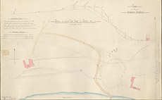

| Title: | Plan of Beaufort Roads: Section of Proposed New Road to Stables |
| Imprint: | 1879 |
| Pagination: | 1 manuscript map: col.; 46 x 72 cm. |
| Shelfmark: | Lovat110 |
| Notes: | 1:40. (20' = 6" ). Courtesy of Lovat Highland Estates and the North of Scotland Archaeological Society. View Lovat Highland Estates mapping |
| Zoom Into Map: | Click on the map to view in greater detail. |