Estate Maps, 1750s-1900s

| Name: | Ordnance Survey |
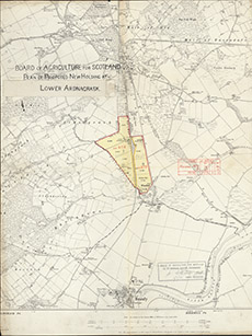
| Title: | Board of Agriculture for Scotland. Plan of Proposed New Holding at Lower Ardnagrask. |
| Imprint: | 1914 |
| Pagination: | 1 map: col.; 52 x 39 cm. |
| Shelfmark: | Lovat087 |
| Notes: | Part of a 1st edition OS map showing a delimited coloured area at Ardnagrask, north of Beauly. Stamped: Board of Agriculture for Scotland 5.11.14. Scale 1:10560. (6" = 1 mile ). Courtesy of Lovat Highland Estates and the North of Scotland Archaeological Society. View Lovat Highland Estates mapping |
| Zoom Into Map: | Click on the map to view in greater detail. |