Estate Maps, 1750s-1900s

| Name: | Boulton, John, 1830-1874 |
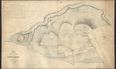
| Title: | [Plan of Part of the Lovat Estate in the Parish of Kiltarlity] |
| Imprint: | 1832 |
| Pagination: | 1 manuscript map: col.; 75 x 126 cm. |
| Shelfmark: | Lovat055 |
| Notes: | Large map, centred on Fanellan and Ruttle Wood, near Kiltarlity Scale 1:3168. (1 chain = ¼" ). Courtesy of Lovat Highland Estates and the North of Scotland Archaeological Society. View Lovat Highland Estates mapping |
| Zoom Into Map: | Click on the map to view in greater detail. |