Estate Maps, 1750s-1900s
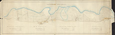

| Title: | [Arable Lands of Crochiels & Inchullie] |
| Imprint: | 1860 |
| Pagination: | 1 manuscript map: col.; 41 x 81 cm. |
| Shelfmark: | Lovat041 |
| Notes: | The date is handwritten on the outside. A map of the farms of Wester Crochiel, Mid Crochiel, Easter Crochiel & Inchullie Scale 1:3658. (10 chains = 5.5 cm ). Courtesy of Lovat Highland Estates and the North of Scotland Archaeological Society. View Lovat Highland Estates mapping |
| Zoom Into Map: | Click on the map to view in greater detail. |