Estate Maps, 1750s-1900s
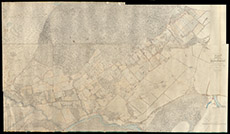

| Title: | Plan of the Part of the Parish of Kilmorack which extends from Ruilick and Teanalonaig to Farley Inclusively, 1876 |
| Imprint: | 1876 |
| Pagination: | 1 manuscript map: col.; 235 x 136 cm. |
| Shelfmark: | Lovat038 |
| Notes: | Parts of the 25" Inverness-shire Mainland OS maps, surveyed in 1871, glued together to show the lands from Ruilick to Farley. Scale 1:2214. (10 chains = 31/8" ). Courtesy of Lovat Highland Estates and the North of Scotland Archaeological Society. View Lovat Highland Estates mapping |
| Zoom Into Map: | Click on the map to view in greater detail. |