Estate Maps, 1750s-1900s

| Name: | Stitt, H., fl. 1826-1866 |
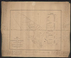
| Title: | Plan from Ordinance Survey of Forest estate lying in the Parish of Rerwick |
| Imprint: | 1858 |
| Pagination: | 1 manuscript map : col.; 43 x 54 cm. |
| Shelfmark: | 114 |
| Notes: | Courtesy of Kirkcudbright Museum through the Dumfries Archival Mapping Project - view futher details. |
| Zoom Into Map: | Click on the map to view in greater detail. |