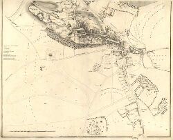
Maps of Scotland
| Field | Content |
|---|---|
| Name: | Wood, John, ca. 1780-1847 |
| Title: | Plan of the Town of Stirling. |
| Imprint: | Edinburgh : [T. Brown], 1820. |
| Pagination: | 1 map on 2 sheets ; sheets 544 x 758 mm. |
| Shelfmark: | EU.31.W |
| Notes: | A coloured version of Wood's map of Stirling also exists showing the jurisdiction of land covered by the Stirling Waterways Act. |
| Zoom Into Map: | Click on the maps below to order image or view in greater detail. |
Top section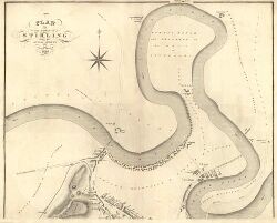
Bottom section