Town Plans / Views, 1580s-1940s
| Field | Content |
|---|---|
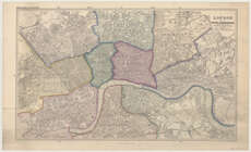
| Name: | Stanford, Edward. |
| Title: | London with its postal sub-divisions / reduced from the map prepared by Edward Stanford ... (Revised ... by B.R. Davies). |
| Imprint: | London : E. Stanford, 1856. |
| Pagination: | 1 map ; 389 x 652 mm. |
| Shelfmark: | Map.l.24.3 |
| Zoom Into Map: | Click on the map to view in greater detail. |
| Notes: | Scale 1:19,800 |