Ordnance Survey small-scale maps of Great Britain, 19th to 20th centuries
(listed chronologically)
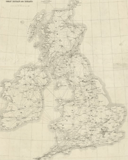
ca. 1852? - Diagram shewing the principal triangulation for the Ordnance Survey of Great Britain and Ireland.
1904 - Ordnance Survey of Great Britain, shewing military districts. Sheet 1 (North), Sheet 2 (Central), Sheet 3 (South)
1905 - Ordnance Survey of Great Britain and Ireland. Sheet 1 (North), Sheet 2 (South)
1906 - Geological map of the British Islands. Based on the work of the Geological Survey.
1906 - Geological map of the British Islands. Based on the work of the Geological Survey.
1924 - Roman Britain.
1928 - Ordnance Survey map of Roman Britain.
1928 - Ordnance survey map of Roman Britain.
1933 - Great Britain 1:1,000,000 (in the style of the International 1/1M map). Sheet 1 (North), Sheet 2 (South)
1933 / 1934 - Population of Great Britain 1931. Sheet 1 (North), Sheet 2 (South)
1933 - Population of Great Britain 1931. Sheet 1 (North), Sheet 2 (South)
1933 - Great Britain 1:1,000,000 (in the style of the International 1/1M. map) With the National Grid. Sheet 1 (North), Sheet 2 (South)
1938 - Britain in the Dark Ages. North sheet, South sheet
1939 - Geological map of the British Islands. Based on the work of the Geological Survey.
1946 - Great Britain.
1956 - Ordnance Survey map of Roman Britain.
1957 - Geological map of the British Islands. Based on the work of the Geological Survey.
1957 - Geological map of the British Islands. Based on the work of the Geological Survey.
1964 - Great Britain.
1965 - Ordnance survey map of Britain in the Dark Ages.
1969 - Great Britain.
1969 - Geological map of the British Islands. Based on the work of the Geological Survey.
1969 - Geological map of the British Islands. Based on the work of the Geological Survey.
1970 - Smoothed aeromagnetic map of Great Britain and Northern Ireland.

