Ordnance Survey Maps - 25 inch 1st edition, Scotland, 1855-1882
Introduction
Map content, printing, reprinting and colouring
In this section
- Background, coverage, surveying and sheet numbering and parish editions
- Detailed map content, printing, reprinting and colouring
Detailed map content

Clackmannanshire.
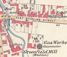
The Ordnance Survey 25 inch maps are a standard topographic authority, depicting practically all human and natural features in the landscape with great accuracy. As for the six inch maps, every road, railway, field, fence, wall, stream and building is shown. There are over 10 different symbols for types of woodland, and uncultivated ground is distinguished into marsh, bog and rough grassland.
The 25 inch scale is four times larger than the six inch, and shows more features in a clearer way:
- Greater detail for all buildings, including divisions between contiguous houses, and even smaller features such as projecting bay windows and steps
- Pavements, garden paths and positions of free standing trees
- Railway tracks and stations in plan form, with many smaller features, such as signal boxes
- Industrial premises, quarries, lime kilns
- Docks, harbours, and quaysides
- All public boundaries, including civil parishes, municipal wards, as well as burgh and county boundaries.
Acreages and Books of Reference

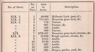
The 25 inch maps record acreages of all land parcels. Land parcels were numbered consecutively within each parish, and acreages of fields were recorded in separate Parish Area Books or Books of Reference. For all of Scotland, apart from Orkney and Shetland, these Books of Reference include land use information. On the map 1.0018 square inches on the map equals one acre on the ground.
- Browse list of Books of Reference by county and parish
- View Books of Reference by volume (with parishes ordered alphabetically)
Printing
Unlike the six inch and one inch maps that were engraved on copper plates, the 25 inch maps were produced by zincography.
Zincography was significantly cheaper, corrections were easier to make, and it was suited to the bold lines and large fonts of the 25 inch scale. The process involved drafting a manuscript plan with litho transfer ink on tracing paper, and the impression transferred to a prepared zinc plate. The zinc plate was then etched with nut galls and phosphoric acid, cleaned, and litho printing ink applied for printing impressions using a hand press.
Lithographic stones had been used at Ordnance Survey from the 1840s, but zinc plates increasingly replaced them from the 1850s. Zinc plates had the advantages of being lighter, and impressions from other copper or zinc plates could be easily copied onto them through electrotyping.
From the 1880s, photo-zincography allowed the automatic reduction of 25 inch maps to the six inch scale through photographic methods, allowing further economies in map production. For this reason, the 25 inch maps developed a bold style and large lettering suitable for reduction to a quarter of the size.
Reprinting
As the 25 inch maps were usually printed through zincography, the original manuscript "fair copy" was kept on paper, and if new copies were needed, it involved retracing it again on a zinc plate for printing. Whilst this did not usually alter the landscape information recorded by the original survey, it did alter the style and presentation of this survey information. The following summary details below are taken from Oliver & Bishop (2016), who deal with the subject in more useful depth.
The presentation of acreages, altitudes and minor detail (such as paths in gardens, and rails under roofed areas) changed between these various states and reprints.
Survey, etc, date: From about 1871 this was included in a publication statement in the bottom centre margin. By 1880 it was in a separate note placed bottom left. This was occasionally supplemented by a note of revision or by a note concerning additional railway information. It should be noted that up to 1888 the date of ‘survey’ was actually that when the fair plan was certified as fit for publication, and that this may be a year or so later than the latest visit to the ground.
Publication date: This was only routinely included on zincographed map sheets from about 1879 onwards. Up to 1887 there was a two-line note, with ‘Zincographed and published’ in italic and the publication date in sans-serif ‘Egyptian’ on a separate line below.
Boundary legend: An explanation of ‘Characteristics and symbols for boundaries &c’ was added to some reprints from the early 1890s onwards. It was produced by transferring from a copper engraved original.
Edition heading: A heading, approximately top centre, in the style ‘FIRST EDITION 18__’ was introduced in about 1894 or 1895, probably at the same time as the publication of the first 1:2500 ‘Second Edition’ sheets.
For further detail on this, see:
R. Oliver & P. Bishop, 'Re-drawing of OS First Edition 1:2500 sheets for a later First Edition printing', Sheetlines 106 (August 2016), pp 43-49. View online.
Colouring
Not all sheets were coloured. Those that were coloured used:
- Blue for water features
- Burnt sienna for roads
- Carmine for buildings made of brick or stone
- Grey for buildings made of wood or iron.
The colour was applied by hand, initially by boys paid on a piece work basis, and later by women.
- View the colours and symbols on the maps and their meaning
