Military Maps of Scotland (18th century)
Your search returned 5 records.
Ordered chronologically (undated items first).
| Field | Content | |
|---|---|---|
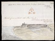
| Title: | Sketch from without the Pier head; Opposite Prince William Henry's Bastion, Fort George, North Britain | |
| Name: | Shipley, Sir Charles (Engineer) | |
| Survey: | 1787 | |
| Shelfmark: | MS.1650 Z.46/57a | |
| Field | Content | |
|---|---|---|
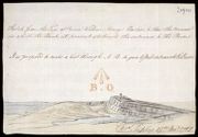
| Title: | Sketch from the Face of Prince William Henrys Bastion, to Shew the Manner in which the Bank at present obstructs the entrance to the bason [Fort George, Ardersier] | |
| Name: | Shipley, Sir Charles (Engineer) | |
| Survey: | 1787 | |
| Shelfmark: | MS.1650 Z.46/57b | |
| Field | Content | |
|---|---|---|
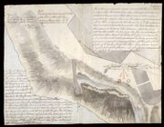
| Title: | A Proposed Prolongation of the Pier head, by a single row of Piles, & Planking, to be drove with the same Slope, as the Pier Viz: one foot in five [Fort George Ardersier] | |
| Name: | Shipley, Sir Charles (Engineer) | |
| Survey: | [1787] | |
| Shelfmark: | MS.1650 Z.46/57c | |
| Field | Content | |
|---|---|---|
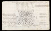
| Title: | Sketch of the Carpenters Work in Ten Feet Running of the Pier at Fort George | |
| Name: | Shipley, Sir Charles (Engineer) Elphinstone, Sir Howard (Engineer) | |
| Survey: | 1787 | |
| Shelfmark: | MS.1650 Z.46/57f | |
| Field | Content | |
|---|---|---|
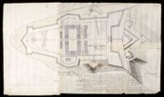
| Title: | Outline of the East End of Fort George with References to the Estimate for Works & Repairs proposed for that place, in the year 1787. | |
| Name: | Shipley, Sir Charles (Engineer) | |
| Survey: | 1787 | |
| Shelfmark: | MS.1650 Z.46/57i | |