Military Maps of Scotland (18th century)
| Field | Content |
|---|---|
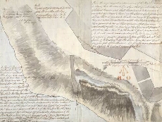
| Title: | A Proposed Prolongation of the Pier head, by a single row of Piles, & Planking, to be drove with the same Slope, as the Pier Viz: one foot in five [Fort George Ardersier] |
| Name: | Shipley, Sir Charles (Engineer) |
| Description: | 1 manuscript map ; 359 x 470 mm. |
| Original Survey: | [1787] |
| Date on Map: | [1787] |
| Placename: | Fort George (Ardersier) |
| Parish: | Ardersier |
| County: | Inverness-shire |
| Shelfmark: | MS.1650 Z.46/57c |
| Zoom Into Map: | Click on the map to view in greater detail. |