Military Maps of Scotland (18th century)
Your search returned 10 records.
Ordered chronologically (undated items first).
| Field | Content | |
|---|---|---|
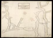
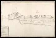
| Title: | The Roads between Innersnait Ruthvan of Badenock Kiliwhiman and Fort William in ye highlands of North Brittain | |
| Name: | Dumaresq, John & Bastide, John Henri (Engineer) Bastide, John Henri (Draughtsman) | |
| Survey: | 1718 | |
| Shelfmark: | MS.1648 Z.03/13a | |
| Field | Content | |
|---|---|---|
| Title: | The Roads between Innersnait Ruthvan of Badenock Kiliwhiman and Fort William in the highlands of North Brittian [1718] [copy] | |
| Name: | Dumaresq, John & Bastide, John Henri (Engineer) Bastide, John Henri (Draughtsman) | |
| Survey: | 1718 | |
| Shelfmark: | MS.1648 Z.03/13b | |
| Field | Content | |
|---|---|---|
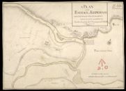
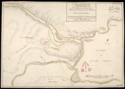
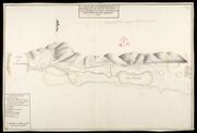
| Title: | A Plan of the Barrack at Kiliwhiman And of the Ground within the bounds of it betwixt the two Rivers & the letters AB.C | |
| Name: | Dumaresq, John & Bastide, John Henri (Engineer) Bastide, John Henri (Draughtsman) | |
| Survey: | 1718 | |
| Shelfmark: | MS.1647 Z.03/08a | |
| Field | Content | |
|---|---|---|
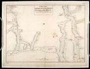
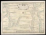
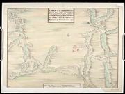
| Title: | A Draught of Innersnait, in the Highlands of North Brittain, nere the Head of Loch Lomend with part of the country adjacent [copy] | |
| Name: | Dumaresq, John & Bastide, John Henri (Engineer) Bastide, John Henri (Draughtsman) | |
| Survey: | [1718] | |
| Shelfmark: | MS.1648 Z.03/15a | |
| Field | Content | |
|---|---|---|
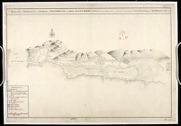
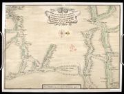
| Title: | A Draught of Innersnait, in the Highlands of North Brittain, nere the Head of Loch Lomend with part of the country adjacent | |
| Name: | Dumaresq, John & Bastide, John Henri (Engineer) Bastide, John Henri (Draughtsman) | |
| Survey: | 1719 | |
| Shelfmark: | MS.1648 Z.03/15b | |
| Field | Content | |
|---|---|---|
| Title: | A Plan of ye Barrack at Kiliwhiman and of the Ground within the Bounds of it betwixt the Two Rivers; and the Letters A.B.C [copy] | |
| Name: | Dumaresq, John & Bastide, John Henri (Engineer) Bastide, John Henri (Draughtsman) | |
| Survey: | 1719 | |
| Shelfmark: | MS.1647 Z.03/08b | |
| Field | Content | |
|---|---|---|
| Title: | A Map of the Roads between Innersnaid Ruthvan of Badenock, Kiliwhiman and Fort William, in the Highlands of North Brittain [1718] 1741[copy] | |
| Name: | Dumaresq, John & Bastide, John Henri (Engineer) Bastide, John Henri (Draughtsman) Coombs, Richard (Copyist) | |
| Survey: | 1741 | |
| Shelfmark: | MS.1648 Z.03/14a | |
| Field | Content | |
|---|---|---|
| Title: | A Map of the Roads between Innersnait, Ruthvan of Badenock, Kiliwhiman and Fort William, in the Highlands of North Brittain [1718] 1741[copy] | |
| Name: | Dumaresq, John & Bastide, John Henri (Engineer) Bastide, John Henri (Draughtsman) Assiotti, Francis Aegidius (Copyist) | |
| Survey: | 1741 | |
| Shelfmark: | MS.1648 Z.03/14b | |
| Field | Content | |
|---|---|---|
| Title: | A Map of the Roads between Innersnaid Ruthvan of Badenock, Kiliwhiman and Fort William in the Highlands of North Brittain [1718] 1741 [copy] | |
| Name: | Dumaresq, John & Bastide, John Henri (Engineer) Bastide, John Henri (Draughtsman) | |
| Survey: | 1741 | |
| Shelfmark: | MS.1648 Z.03/14c | |
| Field | Content | |
|---|---|---|
| Title: | A Draught of Innersnait, in the Highlands of North Brittain, nere the Head of Loch Lomend with part of the country adjacent [copy] | |
| Name: | Dumaresq, John & Bastide, John Henri (Engineer) Bastide, John Henri (Draughtsman) | |
| Survey: | 1742 | |
| Shelfmark: | MS.1648 Z.03/15c | |