Military Maps of Scotland (18th-19th centuries)
Further Information
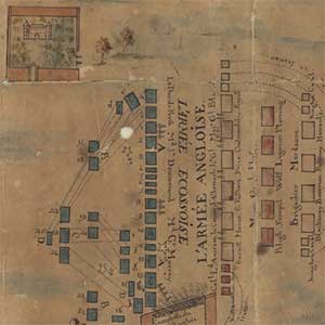
During the 18th century, the threat and reality of Jacobite rebellion in Scotland led to a significant militarisation of the country by government forces. Several medieval and Cromwellian forts were repaired and redeveloped, and wholly new garrisons were planned and constructed. In addition, over 250 miles of military roads were built to link the network of new forts, along with over 40 new bridges. These developments are graphically depicted in the unique manuscript maps from the National Library of Scotland's Board of Ordnance and Wade collections which are included in this website. Collectively numbering nearly 400 items, they include detailed architectural plans, profiles and elevations of forts and buildings; town plans and views; road plans; battle plans; plans of harbour developments; and marine charts. Whilst over half of the maps relate to four major fortifications, namely, Edinburgh Castle, Fort Augustus, Fort George at Ardersier, and Fort William, over 30 other fortifications are also covered, extending from Ayr in the south to Fort Charlotte in Shetland in the north. Chronologically, they span the entire 18th century and the first two decades of the 19th century, with about half the plans dating from between 1720 and 1750.
The sections below give the background to the Board of Ordnance and Wade collections, describe their value as historical sources, provide a historical background explaining the context in which the maps were made, and conclude with suggestions for further reading.
View Military Maps of Scotland (18th century)
Background
The origins of the Board of Ordnance go back to the 14th century, when the English Wardrobe of Arms developed into the Privy Wardrobe of the Tower, which specialised in the provision of arms. Enlarged by Henry VIII of England, it was formally constituted as a Board in 1597, with responsibilities not only for armaments and munitions, but also for the upkeep and repair of forts and castles. As such, it could be regarded as the first permanent military department in England, administratively separate from the Army and Navy.
The Board was initially a civilian body, although by the 18th century - when, following the Union, it was a department of the British government - it maintained both civil and military wings. Many of the surveyors and draughtsmen who designed fortifications and barracks (including those in 18th-century Scotland) were civilians. However, with the expansion of the military from the late 17th century, a large standing army of artillery and engineers came under the Board's control, numerically and politically eclipsing the civilian members of the Board. By the 19th century, the Board was increasingly dominated by army officers and was closely linked to the army, paving the way for the abolition of the Board and the merging of its duties with that of the War Office in 1855. Due to its long history and the dispersed location of forts, Board of Ordnance documents today survive in a number of places. Although the majority of the Board of Ordnance's archives are in the Public Record Office in London (in the WO78 class), there are significant collections of Board of Ordnance maps elsewhere, particularly in the Royal Library in Windsor Castle, and in the British Library in London. The Board of Ordnance maps relating to Scotland were deposited in the National Library of Scotland by the War Office in 1934 (MSS. 1647-1651).
General George Wade (1673-1748) was born in Ireland, but was involved in military service in Flanders, Portugal and Spain between 1692 and 1714, becoming a Brigadier General by 1708 and a Major General by 1714. Commissioned by King George I to report on the growing threat of Highland insurrection in 1724, Wade recommended a number of urgent measures, including the upgrading of forts and the improvement or construction of new roads between them. Within a month, Wade was established as Commander in Chief of His Majesty's forces, castles, forts and barracks in North Britain, and was charged with implementing his recommendations. He occupied this position until 1740.
During these sixteen years in Scotland he was responsible for founding and constructing two new forts, Fort George (Inverness) and Fort Augustus, and upgrading several others, including Perth, Ruthven, Edinburgh and Dumbarton. He was also responsible for constructing about 40 bridges and over 250 miles of roads between these forts, particularly along the Great Glen, and from Dunkeld and Crieff to Fort Augustus and Inverness. He also had plans for further road developments, many of which were carried forward by his successor, William Caulfeild, after 1740.
There are 17 plans in the Wade Collection, on 14 sheets of paper. These complement the Board of Ordnance plans by providing additional illustrations of the construction of barracks and roads in Scotland in the 18th century. Only five are dated, their dates ranging from 1724 to 1736, but although the remaining items are undated, they probably relate to the same time period. The Wade collection includes both maps of large areas of Scotland showing projected roads, and detailed plans showing projected forts at Fort Augustus, Fort William, and Inverness. Also included are plans of the Earl of Gowrie's house in Perth. The collection was gifted to the Royal Scottish Geographical Society around 1923, along with some engraved maps, and the manuscript component of the collection was purchased from them by the National Library of Scotland in 1992 (Acc.10497).
Most of the military maps on this website consist of architectural drawings of forts and castles, using conventions for shading, colour and design that are standard on many other military maps of this period. As such, they are uniquely important not only for architectural, military and cartographic historians, but also for those more generally interested in the development of fortifications and 18th-century Scottish history. For example, the earliest surviving town plans for Inverness, Fort William, Perth and Stirling are from the Board of Ordnance collection, along with the earliest detailed road mapping in some glens, which pre-dates the Taylor and Skinner road maps by 30 to 50 years. The plans themselves can be used to trace the changes and repairs to particular forts, and can also shed light on wider issues such as the Jacobite rebellions of the 18th century and government responses to them. For example, there are battle plans of Sheriffmuir (1715), Glenshiel (1719), Prestonpans (1745), Falkirk (1746), and Culloden (1746), as well as plans for the construction of new defences and roads in response to the Jacobite insurrections.
Unfortunately, dating the plans can sometimes be difficult. First, nearly a third of the maps have no date, and over a third have no indications of authorship, thus making it only possible to infer their date from a knowledge of the fort depicted. Second, because the copying of earlier plans was an essential part of the training for Board of Ordnance draughtsmen, the collection often includes later copies of an original earlier plan, all of which survive. Often, though, on copied plans, the copyist is named and his function as copyist made clear.
Partly in response to anti-Union feelings and James Francis Edward Stuart's abortive uprising in 1708, the castles of Edinburgh, Stirling and Fort William were all upgraded in the early part of the 18th century. These works were carried out under the particular guidance of Captain Theodore Dury, who had succeeded the more famous John Slezer as the Board of Ordnance's chief engineer in 1708. Much more serious military activity followed the death of Queen Anne in 1714 and her succession by King George. With the growing discontent amongst Jacobites harnessed into a rebellion under John, Earl of Mar, not only was Edinburgh Castle nearly captured in 1715, but Perth itself fell to the Jacobites, and armies clashed at the indecisive battle of Sheriffmuir, near Dunblane. All these events and their aftermath are recorded in the plans on this website, the earliest of which dates from 1700.
One of the main responses to the political situation was a programme of new barrack construction, including Berwick in 1717, and the construction of four new forts at the important strategic cross-routes of Inversnaid by Loch Lomond, Bernera in Glenelg, Kiliwhimen (at the bottom end of Loch Ness) and Ruthven in Badenoch. These followed the designs of the engineers Andrew Jelfe and John Romer (one of the Board's finest military engineers, who left a considerable legacy in Scotland). In 1719 the Jacobites attempted to join the Spanish Duke of Ormonde in an invasion in the north-west, and were confronted by an army led by General Wightman at the pass of Glenshiel. The resulting battle is recorded in another battle plan in the collection.
By the 1720s it was clear that the Jacobite threat had to be countered with more direct intervention, and from 1724, in response to his own report and recommendations on what should be done, General George Wade was appointed Commander-in-Chief, North Britain. Although he is chiefly remembered for the network of military roads and bridges constructed at this time, many of these were only planned by Wade, and left to his successor, William Caulfeild, to actually construct in the 1740s and 1750s. Nevertheless 250 miles of roads were built under Wade's supervision, particularly the road up the Great Glen between Fort William and Inverness, and the roads linking Dunkeld, Crieff, Fort Augustus, and Inverness.
General Wade also initiated and supervised the construction of two new forts, at Inverness and Kiliwhimen, both based on John Romer's designs. Fort George at Inverness was constructed from 1727, altering the original medieval tower house, and tactically named in honour of George II, who had ascended the throne two months earlier. Due to the problems of the original fortress at Kiliwhimen, a grand new fort, Fort Augustus, was planned and constructed from 1729, although not completed until 1742. This magnificent garrison was named in honour of George II's third son, William Augustus, who in the 1740s became better known as the Duke of Cumberland or 'Butcher' Cumberland. Both these forts, and the work on them over two decades, are well illustrated in the collection.
During this time work also continued on Ruthven, Edinburgh, and Dumbarton, with the construction of new governors' houses and barracks.
The various forts' defences were not properly tested until August 1745, when Charles Edward Stuart raised his standard at Glenfinnan, initiating the '45 uprising. Some forts, such as Inversnaid and Fort Augustus, fell quite quickly, whilst others (eg. Ruthven, Edinburgh and Stirling) held out under siege for longer. The routes taken by the Jacobite and Hanoverian armies in 1745-6, along with sites of battles are shown on two maps of Great Britain (ca. 1747). By the time of the decisive battle of Culloden nine months later (illustrated in this collection) many of the forts had been badly damaged and were in need of repair. This in turn required plans and proposals to be drawn up, particularly by the engineers Lewis Marcell and William Skinner.
The British army were extremely embarrassed by how quickly some of their forts had fallen, and now began to plan and construct a massive new fortification, Fort George at Ardersier Point. This took over 23 years to complete, and is very well illustrated in the collection with barracks from 1753, the grand magazine from 1757 to 1759, the staff block from 1762 to 1766, and a chapel in the final stages. When complete, it was easily the largest barracks in Britain, able to house 1,600 men, or two whole infantry divisions: a deliberately impressive military and political statement. William Skinner, the Board's chief military engineer, was responsible for its design and execution, a project that cost over £200,000 (twice his original estimate), and he became the first governor of the fort.
Another aspect of the post-1745 strategy consisted of fortifying older forts in remoter parts of the country to form focal points for patrols. Some detailed plans and attractive views exist of Castles Duart, Tioram, Braemar, and Corgarff, and of Fort Augustus, amongst other places, from the late 1740s to the 1760s. Some of these were by the brothers Thomas and Paul Sandby, who were also involved in the Roy Military Survey of Scotland. Paul Sandby also went on to become a notable landscape artist, 'the father of English watercolour'. It is also possible that some of the plans at this time (1747-55) derive from William Roy himself, during his time in Scotland overseeing his Military Survey.
In the 1780s, concern over American privateers led to a decision to re-establish Fort Charlotte (named after George III's Queen) in Lerwick, Shetland. The construction of this fort had begun over a century earlier in the 1660s, particularly to counter Dutch threats, but was left incomplete. Although constructed with barracks for 270 men, officers' lodgings, a powder magazine, and extensive ramparts, the fort was occupied relatively briefly, and was never the subject of any attack.
The final plans in the collection date from the 1790s, and primarily show enhancements to existing fortifications (such as those at Leith, Edinburgh, and Fort William), and occasional new works (such as those in Aberdeen). These reflect the growing concerns over a Napoleonic invasion. Fortunately for the forts, this never occurred, and their military role gradually declined in the 19th century, leaving many impressive structures which can still be seen and visited today.
- Anderson, Carolyn, 'Constructing the military landscape: the Board of Ordnance maps and plans of Scotland, 1689–1815', PhD diss., University of Edinburgh, 2010. View PDF online.
- Anderson, Carolyn and Christopher Fleet, Scotland: Defending the Nation. Mapping the Military Landscape (Edinburgh: Birlinn in association with the National Library of Scotland, 2018). Chapter 5. The Roy Military Survey to Fort George, Ardersier, 1746-1787.
- Douet, J., British Barracks, 1600-1914 (London, 1998)
- Gifford, J., The Buildings of Scotland: Highlands and Islands (London, 1992)
- Lenman, B., The Jacobite risings in Britain 1689-1746 (Aberdeen, 1995)
- Lenman, B., & Gibson, J., The Jacobite threat: rebellion and conspiracy 1688-1759 (Edinburgh, 1990)
- Marshall, D.W., 'Military maps of the eighteenth-century and the Tower of London Drawing Room', Imago Mundi, 32 (1980), 21-44
- Porter, W., History of the Corps of Royal Engineers, vol. 1 (London, 1889)
- Royal Scottish Geographical Society, The early maps of Scotland to 1850, 3rd ed. (Edinburgh, 1973-83)
- Salmond, J.B., Wade in Scotland (Edinburgh, 1938)
- Saunders, A., Fortress Britain: artillery fortification in the British Isles and Ireland (London, 1989)
- Tabraham, C. & Grove, D., Fortress Scotland and the Jacobites (London, 1995)
- Taylor, W., The military roads in Scotland (London, 1976)