Military Maps of Scotland (18th century)
Your search returned 16 records.
Ordered by maps relating to the whole county first, then alphabetically by parish.
| Field | Content | |
|---|---|---|
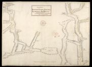
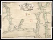
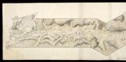
| Title: | The Roads between Innersnait Ruthvan of Badenock Kiliwhiman and Fort William in ye highlands of North Brittain | |
| Name: | Dumaresq, John & Bastide, John Henri (Engineer) Bastide, John Henri (Draughtsman) | |
| Original Survey: | 1718 | |
| Shelfmark: | MS.1648 Z.03/13a | |
| Field | Content | |
|---|---|---|
| Title: | The Roads between Innersnait Ruthvan of Badenock Kiliwhiman and Fort William in the highlands of North Brittian [1718] [copy] | |
| Name: | Dumaresq, John & Bastide, John Henri (Engineer) Bastide, John Henri (Draughtsman) | |
| Original Survey: | 1718 | |
| Shelfmark: | MS.1648 Z.03/13b | |
| Field | Content | |
|---|---|---|
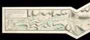
| Title: | [Sketch and description of the proposed Roads from Callander and Loch Tay to Fort William and Appin including details of mileage and of inns] | |
| Name: | [Wade, George (Engineer)] | |
| Original Survey: | [ca. 1724-45?] | |
| Shelfmark: | Acc.10497 Wade.58m | |
| Field | Content | |
|---|---|---|
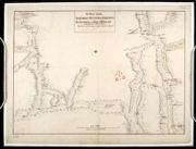
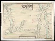
| Title: | A Map of the Roads between Innersnaid Ruthvan of Badenock, Kiliwhiman and Fort William, in the Highlands of North Brittain [1718] 1741[copy] | |
| Name: | Dumaresq, John & Bastide, John Henri (Engineer) Bastide, John Henri (Draughtsman) Coombs, Richard (Copyist) | |
| Original Survey: | 1741 | |
| Shelfmark: | MS.1648 Z.03/14a | |
| Field | Content | |
|---|---|---|
| Title: | A Map of the Roads between Innersnait, Ruthvan of Badenock, Kiliwhiman and Fort William, in the Highlands of North Brittain [1718] 1741[copy] | |
| Name: | Dumaresq, John & Bastide, John Henri (Engineer) Bastide, John Henri (Draughtsman) Assiotti, Francis Aegidius (Copyist) | |
| Original Survey: | 1741 | |
| Shelfmark: | MS.1648 Z.03/14b | |
| Field | Content | |
|---|---|---|
| Title: | A Map of the Roads between Innersnaid Ruthvan of Badenock, Kiliwhiman and Fort William in the Highlands of North Brittain [1718] 1741 [copy] | |
| Name: | Dumaresq, John & Bastide, John Henri (Engineer) Bastide, John Henri (Draughtsman) | |
| Original Survey: | 1741 | |
| Shelfmark: | MS.1648 Z.03/14c | |
| Field | Content | |
|---|---|---|
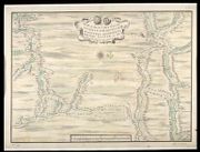
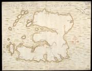
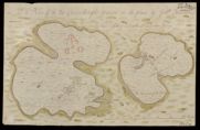
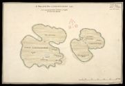
| Title: | A Plan of the Island of Mull with the adjacent Islands Drawen on the place | |
| Name: | Johnson, Robert (Overseer) | |
| Original Survey: | [1741] | |
| Shelfmark: | MS.1648 Z.03/23a | |
| Field | Content | |
|---|---|---|
| Title: | A Plan of the Island of Mull with the adjacent Islands [copied] 1741 | |
| Name: | Johnson, Robert (Overseer) | |
| Original Survey: | 1741 | |
| Shelfmark: | MS.1648 Z.03/23b | |
| Field | Content | |
|---|---|---|
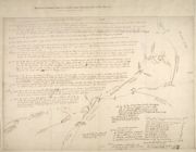
| Title: | A Survey of the Road made by the Detachmt. Of Genl. Guise's Regt. In Brae Marr; beginning where Genl. Blakeney's left off; & Continue'd to the Spittle of Glen-Shee 1749 | |
| Name: | Archer, John (Engineer) | |
| Original Survey: | 1749 | |
| Shelfmark: | MS.1649 Z.03/32a | |
| Field | Content | |
|---|---|---|
| Title: | A Survey of the Road made by the Detachment. Of Genl. Guise's Regt. In Brae Marr; begining where Genl. Blakeney's left off; & Continued to the Spittle of Glen Shee 1749 [copy] | |
| Name: | Archer, John (Engineer) | |
| Original Survey: | 1749 | |
| Shelfmark: | MS.1649 Z.03/32b | |
| Field | Content | |
|---|---|---|
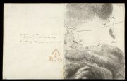
| Parish: | Campbelton | |
| Title: | [Sketch plan of Town, Harbour and Battery at Campbeltown, with report] | |
| Name: | Gravat, William (Engineer) | |
| Original Survey: | 1795 | |
| Shelfmark: | MS.1649 Z.03/56h | |
| Field | Content | |
|---|---|---|
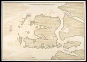
| Parish: | Kilninian and Kilmore | |
| Title: | A Plan of the Two Carrinburghs drawen on the place | |
| Name: | Johnson, Robert (Overseer) | |
| Original Survey: | [1717] | |
| Shelfmark: | MS.1648 Z.03/24a | |
| Field | Content | |
|---|---|---|
| Parish: | Kilninian and Kilmore | |
| Title: | A Plan of the Two Carrinburghs 1741 [copy] | |
| Name: | Johnson, Robert (Overseer) | |
| Original Survey: | 1741 | |
| Shelfmark: | MS.1648 Z.03/24b | |
| Field | Content | |
|---|---|---|
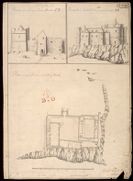
| Parish: | Torosay | |
| Title: | Plan of Castle Dwart in the Island of Moll; Prospect of the Front of Castle Dwart CD; Prospect of Castle Dwart from the Sea markt AB | |
| Name: | Petit, Lewis (Engineer) | |
| Original Survey: | [1714] | |
| Shelfmark: | MS.1648 Z.03/28a | |
| Field | Content | |
|---|---|---|
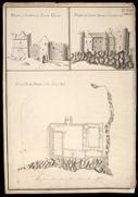
| Parish: | Torosay | |
| Title: | Plan of Castle Douart in the Isle of Mull [copied between 1755 and 1759]; Prospect of the Front of Castle Douart; Prospect of Castle Douart from the Sea | |
| Name: | Petit, Lewis (Engineer) Mulcaster, Frederick (Engineer) | |
| Original Survey: | [1714] | |
| Shelfmark: | MS.1648 Z.03/28c | |
| Field | Content | |
|---|---|---|
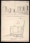
| Parish: | Torosay | |
| Title: | Plan of Castle Dwart in the Island of Mull [copy] 1741; Elevation at C,D. Elevation at A,B. | |
| Name: | Petit, Lewis (Engineer) | |
| Original Survey: | 1741 | |
| Shelfmark: | MS.1648 Z.03/28b | |